Noise Mapping & Modelling
Noise mapping and acoustic modelling uses calibrated 3D propagation software to predict sound levels across a site or area, providing the spatial data needed for planning, EIA and masterplanning decisions.

Noise Mapping and Modelling — What It Involves
Without accurate noise mapping, developers and planners lack the spatial evidence needed to assess how noise distributes across a site, identify the most exposed receptors and demonstrate that proposed mitigation will be effective. Decisions made without modelled data risk under-specifying facade treatment on the worst-affected plots and over-specifying on those with acceptable exposure.
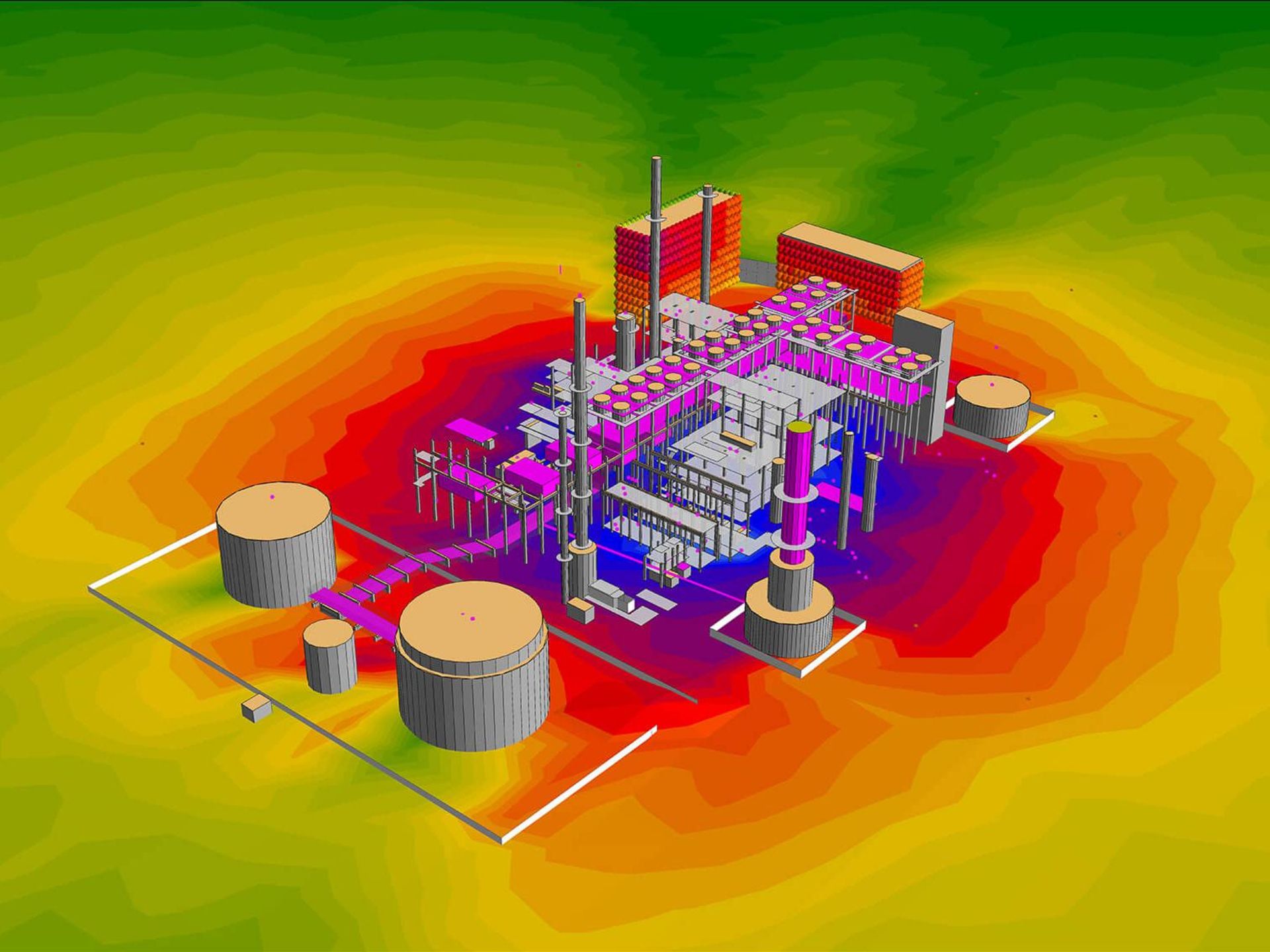
Noise mapping involves building a calibrated 3D acoustic model of the site and its surroundings, incorporating terrain, buildings, barriers and noise sources — roads, railways, industrial plant or proposed development. The model predicts sound pressure levels across the site as colour-coded contour maps and at discrete receptor positions, in accordance with BS ISO 1996 and computation methods such as CRTN, CRN or ISO 9613-2.
Why is noise mapping important for your project?
Spatial planning evidence
Noise contour maps show at a glance where on a site noise exposure is highest, allowing architects and masterplanners to position noise-sensitive uses, including bedrooms, living spaces and amenity areas, away from the worst-affected zones. This evidence is expected by local planning authorities on larger or more complex sites.
Mitigation effectiveness tested
Acoustic models allow noise barriers, bunds, building orientation and facade treatments to be tested and refined before construction begins. Iterating in the model is significantly faster and cheaper than discovering inadequate attenuation after completion
Planning and EIA compliance
EIA noise chapters and planning applications for major developments require spatial noise data presented as contour maps. A calibrated model produced to BS ISO 1996 standards provides the technical rigour expected by planning authorities and statutory consultees.
Occupant wellbeing by design
Noise contour modelling at masterplanning stage allows site layouts to be configured so that the most noise-sensitive uses are positioned away from dominant noise sources before site apportionment decisions are fixed. Relocating a residential block or repositioning a service yard costs nothing at concept stage; achieving the same outcome through facade treatment, operational restrictions or condition compliance after planning consent is materially more expensive and disruptive.
What standards govern noise mapping and modelling?
Noise mapping for planning and EIA purposes is carried out using calculation methods appropriate to the source type. Road traffic noise is calculated to Calculation of Road Traffic Noise (CRTN), the UK government-approved prediction method. Railway noise is calculated to Calculation of Railway Noise (CRN). For general industrial, commercial and mixed sources, ISO 9613-2:1996 provides an internationally recognised outdoor sound propagation method accounting for ground attenuation, barrier insertion loss and meteorological effects. For strategic noise mapping under the Environmental Noise Regulations 2006, CNOSSOS-EU methods apply to major roads, railways, airports and industrial sites above defined traffic thresholds.
Predicted noise levels are presented as contour maps showing spatial exposure across a site or study area, with results expressed in the metrics appropriate to the assessment: LAeq for planning applications, Lden and Lnight for strategic mapping. Contour data is used to identify the noise exposure of proposed development, assess the effectiveness of mitigation measures and demonstrate to planning authorities that development is acceptable in the context of NPPF noise policy. Modelling outputs are validated against monitored baseline data where possible to establish calibration confidence.
Reporting and submission
Data gathering and model build
We assemble the inputs required for the acoustic model, including terrain data, Ordnance Survey building heights, traffic flows, rail timetables and industrial source data, and construct a 3D model of the site and its surroundings in specialist propagation software. Source data is verified against measured levels where available to ensure the model is calibrated before results are extracted.
Baseline validation
Predicted noise levels at representative positions are compared against measured background and source data to validate model accuracy. Any discrepancies are investigated and the model is adjusted so that predicted and measured levels are in agreement before scenario testing begins.
Scenario testing and optimisation
Proposed mitigation measures — barriers, bunds, building orientation, facade specifications — are modelled iteratively to identify the most cost-effective combination that brings receptor levels within the required criteria. Results are extracted as contour maps and receptor-specific level tables for use by the design team and planning consultant
Reporting and submission
A noise mapping report is produced documenting the model inputs, validation data, methodology, scenario results and recommended mitigation, formatted for inclusion in a planning application, EIA noise chapter or Environmental Health submission. Contour maps are produced at scales and in formats specified by the planning authority or EIA coordinator
Questions
Find answers to common questions about noise assessment and compliance.
Noise contour mapping is typically required for larger or more complex developments where a simple point-source assessment cannot adequately represent how noise varies across the site — for example, multi-plot residential schemes near major roads or railways, mixed-use developments with proposed industrial or commercial noise sources, and any application requiring an EIA noise chapter. The local planning authority will advise at pre-application stage, but early modelling informs site layout decisions that are difficult to reverse later.
We use industry-standard acoustic propagation software capable of implementing CRTN, CRN and ISO 9613-2 calculation methods within a calibrated 3D model. Software outputs include receptor-level tables, horizontal and vertical contour maps, and facade-level predictions suitable for ProPG assessment and BS 8233:2014 compliance reporting. The choice of calculation method is determined by the dominant noise source and the requirements of the local planning authority
BS ISO 1996 sets the framework for environmental noise assessment; CRTN and CRN are the prescribed methods for road and railway noise prediction; and ISO 9613-2 governs industrial source modelling. The Environmental Noise Regulations 2006 apply to strategic noise mapping for major infrastructure. NPPF noise policies and ProPG guidance govern how modelling results are interpreted in the planning process for residential development
The core inputs are terrain and building height data, noise source data — typically Annual Average Daily Traffic flows and speeds for roads, train frequency and type for rail, or sound power levels for industrial plant — and the positions of receptor points or calculation grids. Where source data is not available from published datasets, we carry out traffic counts or noise measurements to establish representative inputs. The quality of the model output depends directly on the accuracy of the inputs, so source verification is a key stage in the process
Where modelling reveals that a significant proportion of the site exceeds BS 8233:2014 or ProPG thresholds, we work through mitigation options in the model — barrier height and position, building orientation, plot layout changes, facade specification — to identify a scheme that achieves acceptable levels across all noise-sensitive uses. If residual levels on certain plots remain elevated after reasonable mitigation, we engage with the planning authority to agree a position under the agent of change principle, supported by the modelled evidence.
Need more information?
Reach out to discuss your assessment needs.
Talk to an Acoustic Consultant
Looking for advice on building acoustics, noise control, environmental assessments, or compliance? Send us a message and we'll respond as soon as possible.


.webp)